

1699
Discovery
On March 28, 1699, Pierre Le Moyne, Sieur d’Iberville and his party camped at Goose Point on the north shore of Lake Pontchartrain, near what would someday become Slidell. This is the first recorded European presence in the Slidell area. New Orleans was founded in 1718, when 300+ settlers arrive and begin the systematic clearing of land by the river. In the early 1700s, French trading posts and small settlements appeared along the north shore of the lake. These north shore trading posts were providing fresh meat and produce, traded from the local Acolapissa people, to help New Orleans survive those early fledgling years.
The Railroad Arrives

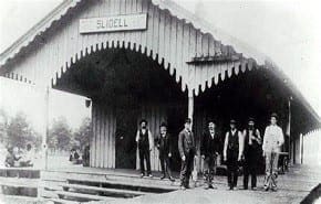
Slidell, Louisiana began to flourish around 1882 during the construction of a major new railroad from New Orleans to Meridian, Mississippi, connecting there with Cincinnati, Ohio, and eventually with New York, NY. The New Orleans and Northeastern (NONE) Railroad established a 70-acre construction site at first high ground north of Lake Pontchartrain that eventually grew into the city.
1882
1888
Slidell Becomes a Town
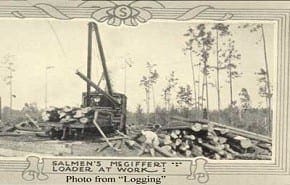
In 1888, the Louisiana State Legislature passed the resolution officially recognizing the Town of Slidell. The train station, originally named in 1883, would provide the name for the new town in 1888 – “Slidell.” Fritz Salmen came to area around this time, starting a small brick company. With the new railroad, the Salmen business grew into one of the largest companies in the South. Salmen Brothers Industries, based in Slidell, became an international business. Other businesses soon followed.
Commerce Boon
By 1910, a community initially called “Salmen Town” had grown just a mile or so from the Slidell Train Station. This was an industrial company town that grew to support the company and employees who worked the Salmen Brothers brickyards, lumber mills, shipbuilding yards, and Railroad Company. The company employed more than 800 local people by this time The Salmen Brothers “Commissary” [merchandise store] in St. Tammany Parish. Soon, lots of other businesses and industries were springing up across the area. The rail line from running from Slidell to Pearl River became an industrial hub in the early 1900s.1910
1930
Population Boon
Growing industries and businesses fueled a growing economy and growing population. The women of Slidell realized the need for religion, social gatherings, and education in the community. The Ladies Aid Societies and Missionary Societies had fundraising events to raise funds for the building of churches and schools in the area. Civic improvements created a community where more and more families came to raise their children and enjoy the social offerings of this small community.NASA Arrives; Slidell Becomes a City
In October 1961, a historic announcement was made; the federal government had selected an area in Hancock County, Miss., to be the site of a static test facility for launch vehicles to be used in NASA’s Apollo lunar landing program. It was the largest construction project in the state of Mississippi and the second largest in the United States at that time. Soon, NASA’s manufacturing complex, The Michoud Assembly Facility, arrived in New Orleans East, and a large NASA Computer Complex was constructed in Slidell. Slidell provided the perfect location for people to live, work, and play. More than 15,000 NASA employees, along with their families, came to the area in the early 1960s. This population boost was enough for Slidell to become a city.1961
2005
Hurricane Katrina
On August 29, 2005, one of the worse hurricanes in U.S. history, Hurricane Katrina, devastated Slidell. Many parts of the city experienced significant damage. In the aftermath, Slidell became home to 1000s of displaced families who had a total loss in New Orleans and places like Chalmette and other cities that lie on the outskirts of New Orleans.
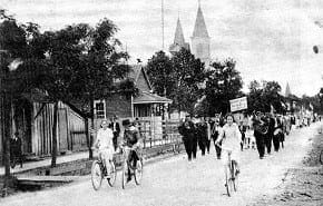
 By 1910, a community initially called “Salmen Town” had grown just a mile or so from the Slidell Train Station. This was an industrial company town that grew to support the company and employees who worked the Salmen Brothers brickyards, lumber mills, shipbuilding yards, and Railroad Company. The company employed more than 800 local people by this time The Salmen Brothers “Commissary” [merchandise store] in St. Tammany Parish. Soon, lots of other businesses and industries were springing up across the area. The rail line from running from Slidell to Pearl River became an industrial hub in the early 1900s.
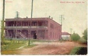 Growing industries and businesses fueled a growing economy and growing population. The women of Slidell realized the need for religion, social gatherings, and education in the community. The Ladies Aid Societies and Missionary Societies had fundraising events to raise funds for the building of churches and schools in the area. Civic improvements created a community where more and more families came to raise their children and enjoy the social offerings of this small community.
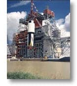 In October 1961, a historic announcement was made; the federal government had selected an area in Hancock County, Miss., to be the site of a static test facility for launch vehicles to be used in NASA’s Apollo lunar landing program. It was the largest construction project in the state of Mississippi and the second largest in the United States at that time. Soon, NASA’s manufacturing complex, The Michoud Assembly Facility, arrived in New Orleans East, and a large NASA Computer Complex was constructed in Slidell. Slidell provided the perfect location for people to live, work, and play. More than 15,000 NASA employees, along with their families, came to the area in the early 1960s. This population boost was enough for Slidell to become a city.
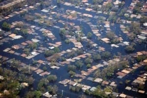 On August 29, 2005, one of the worse hurricanes in U.S. history, Hurricane Katrina, devastated Slidell. Many parts of the city experienced significant damage. In the aftermath, Slidell became home to 1000s of displaced families who had a total loss in New Orleans and places like Chalmette and other cities that lie on the outskirts of New Orleans.
Slidell, Louisiana’s foundations were laid in 1882 when the New Orleans and Northeastern [NONE] Railroad surveyors mapped out a new route eastward from New Orleans. The new route would connect New Orleans directly to Meridian, Mississippi, and destinations in the eastern United States. Surveyors made their way through the wetlands of New Orleans East, then crossed five-miles of water on Lake Pontchartrain, and then more wetlands on the north shore until reaching what would soon become the town “Slidell.” The NONE Railroad Company established an industrial 70-acre construction site near Bayou Bonfouca and began work on the new line. The railroad bridge that they built was the first bridge to cross Lake Pontchartrain. It was the long RR Bridge in the world when built. It was considered and engineering marvel at the time. Soon, the population in the area had grown sufficiently for the Louisiana State Legislature to grant a charter to the growing community, and Slidell officially became a town on November 13, 1888.
Sometime prior to Slidell’s formal incorporation in 1888, its first streets had already been laid out in a grid pattern, mostly east of the railroad, running three blocks along the railroad by four blocks deep. Bonfouca Street, now Bayou Lane, lay in the short stretch between the railroad and the bayou. East of the tracks, the north-south streets were Bayou (now Front), First, Second, Third, and Fourth. The east-west streets were Fremaux, Erlanger, Bouscaren, and Cousin.
Erlanger, slightly wider than the others and designated as an avenue, was named for Baron Frederick Erlanger, head of the banking syndicate which financed the railway. Baron Erlanger named the town for his deceased father-in-law, John Slidell, who had been a prominent state, national and confederate political figure. Col. Leon J. Fremaux, a prominent Louisiana engineer and planner, drew the original plans for Slidell and Fremaux Avenue now bears his name. Bouscaren Street was named for G. Bouscaren, the chief engineering officer of the railroad, and Cousin [‘Coo-zan’] Street took its name from a locally prominent family.

Baron Frédéric Émile d’Erlanger

Napoléon Josèph “Léon” Frémaux

Louis Gustave Frederick Bouscaren
After its founding, Slidell was home to one of the largest creosote plants in the world, one of the country’s largest brick manufacturing facilities, several large lumber mills, and a shipyard. The shipyards in Slidell contributed significantly to the national war effort in both World Wars. Many Slidell residents worked in New Orleans ship, tank, and airplane construction during World War II.
In the 1960s, Slidell began to assume its modern profile as the middle of three local sites in NASA’s lunar landing program: Michoud assembly facility in New Orleans East, a large computer facility in Slidell, and the Mississippi test facility in Hancock County, Mississippi; now the Stennis Space Center.
Slidell is located at the southeastern tip of St. Tammany Parish in Louisiana’s famous Ozone Belt. It is about three miles from the north shore of Lake Pontchartrain and is surrounded by rivers and bayous. The largest municipality in the parish, Slidell has grown from a population of 364 in 1890 to 24,142 in 1990; Slidell’s 1999 population was estimated to be 32,000. Today, Slidell continues to deal with urban planning and growth, while preserving a sense of present and past. Slidell is a dynamic community accommodating an ever-increasing number of residents and businesses seeking quality living and expanding opportunity.
Slidell Museum


Located inside the old Town Hall & Marshall’s Office, the museum displays photographs, collections, and memorabilia on the history of Slidell. The friendly and helpful staff love to share interesting stories reflecting Slidell’s rich history and heritage. Tours are both educational and entertaining drawing visitors from all over; including many international visitors. This a fantastic way to spend some quality time with family and friends, or just a quiet afternoon in a relaxing atmosphere.
The second floor of the building is home to Slidell’s Mardi Gras Museum, which houses a collection of over 800 pieces of Carnival memorabilia-dresses, costumes, scepters, goblets and throws, and historical scrapbooks of past kings and queens. This is an excellent place to visit with out-of-town guests who may not have had the opportunity to experience Mardi Gras first hand.
For more interesting historical information about Slidell, check out the Slidell Museum’s “Slidell’s Historic Sites” or, use the QR code below.